The Artists
Albert Charles Cooke
ALBERT CHARLES COOKE
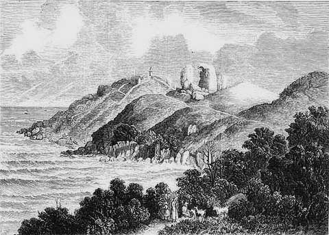
THE SKULL ROCKS AND LANDING PLACE, WILSON'S PROMONTORY, 1876
ALBERT CHARLES
COOKE
Born 1836, Died 1902
THE SKULL ROCKS AND LANDING PLACE, WILSON'S PROMONTORY,
1876
print: wood engraving
Published in
the Illustrated Australian News
Melbourne: Ebenezer and David Syme, January 26, 1876
Collection: La Trobe Picture Collection
State Library of Victoria
This wood engraving by Albert Charles Cooke depicts the lighthouse atop South East Point, and to its left a small shack. Closer to the viewer, and north of the lighthouse are the 'Skull Rocks', not to be confused with Skull Rock which is situated off the coast of Wilsons Promontory, to the south west of Anser Island.
At the base of the cliffs, below the lighthouse in the partially protected bay illustrated here, is the 'Landing Place' which is illustrated in more detail in the work 'Landing Passengers at Wilson's Promontory'.
It is interesting to note that depicted in the foreground of this wood engraving are children who appear to be attending goats. It is possible that goats were kept there at that time to provide a source of fresh milk for the lighthouse keeper and any visitors. It is also likely that goats were chosen in preference to cattle, as they were more suited to the rocky terrain.
The manned lighthouse is called the South East Point Lighthouse. It was built in 1859, using convict labour, and stands on a giant base of granite. A year after it was built, a telegraph line was laid from Foster, connecting Yanakie, Darby River, Mount Oberon and the lighthouse. The lighthouse today is a popular spot for visitors to Wilsons Promontory National Park, and is situated approximately eighteen and a half kilometres south east of Tidal River Resort.
Wilsons Promontory has 160 kilometres of coastline, and early artworks, such as this wood engraving, show that it has some of the most rugged coastal terrain of any part of the Victorian coastline.
Wilsons Promontory National Park, which is approximately 49000 hectares in size, is about forty kilometres north to south, and varies between nine to twenty two kilometres east to west. This area of Victoria has had a long association with the Aborigines, and was occupied predominantly by the Brataualung clan, one of the five clans of the larger tribe known as the Kurnai. Evidence of Aboriginal settlement of 'The Prom', dating back 7500 years, has been unearthed at Darby Bay.
'The Prom' is also an area of great geological significance. The high mountain range can be traced back to sometime in the Devonian Period, 395-350 million years ago, when molten rock pushed its way up into overlying rock deposits, where it cooled and solidified into granite. Over millions of years the overlying rocks were eroded exposing the granite mass. This in itself was eroded, although as happens with granite, it eroded unevenly. What was left was a spine of rugged granite peaks of various shapes and sizes that was once connected by land to Tasmania.
In one report it is noted that the mountainous spine of Wilsons Promontory, 'was part of the high land that formed a bridge extending in a south easterly direction, (past South East Point, as depicted in this wood engraving), across what is now Bass Strait, through the Hogan, Curtis and Kent Groups of Islands, to Flinders Island, and Tasmania's north east.'
Since the end of the Tertiary Period, two million years ago, the sea has fallen and risen at least four times as World climates changed during the Ice Ages. The last major land connection was only some 12000 years ago. Some consider that Wilsons Promontory was an island about 4000 years ago, until the sand built up in the south west to form the Yanakie isthmus, thus joining 'The Prom" to the rest of Victoria. However, if this was the case, than the Aboriginal archaeological finds at Darby Bay, dating back 7500 years, make for considerable speculation.
The sea around Wilsons Promontory is dotted with islands that were once linked to the land bridge to Tasmania. All the islands close to 'The Prom'; Doughboy, Granite, Bennison, Rabbit, Rabbit Rock, Wattle, Norman, Shellback and the Anser and Glennie Groups are included in the Wilsons Promontory National Park. However, Rodondo Island and those islands further away fall within the State of Tasmania, as the Victorian State boundary extends only seven kilometres south of the lighthouse.
Further information on the artist, Albert Charles Cooke is provided with the entry for his work 'Queenscliff'.
Copyright
Notice
No works
can be copied from this site. Permission to publish or reproduce can be
sought from the
State Library of Victoria.
All Rights Reserved medialaunch Pty. Ltd.
Left:
Arthur Streeton - Above Us The Great Grave Sky, 1890
Collection: National Gallery of Australia, Canberra.
ABN 69 067 524 921
Tel: +61 3 98185700 Fax: +61 3 98185044
Email: editor@artistsfootsteps.com