The Artists
HOLIDAY
RAMBLES - APOLLO BAY AND CAPE OTWAY, 1881
BLANKET
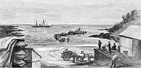
BAY, LANDING STORES FOR CAPE OTWAY
HOLIDAY RAMBLES:
APOLLO BAY AND CAPE OTWAY, 1881
Engraving no 6: BLANKET BAY, LANDING STORES FOR CAPE OTWAY
print: wood engraving
Published in the Illustrated Australian News
Melbourne: David Syme & Co., May 4, 1881
Collection:
La Trobe Picture Collection
State Library of Victoria
Cape Otway is situated 229 kilometres south west of Melbourne and is the southernmost part of the Otway Range. It is also with Wilsons Promontory one of the most southerly points on the Australian mainland, and one of the wettest parts of Victoria.
Lieutenant James Grant of the 'Lady Nelson' named the cape in December 1800, in honour of his friend, Captain William Albany Ottway of the Royal Navy. The name, Cape Albany Ottway, was later changed to Cape Otway, and was extended to cover the Range.
Much of the Otway Range is in the 12750 hectare Otway National Park. The Cape Otway Lighthouse is however not included in the National Park. The Cape Otway Lighthouse is the oldest on the Victorian coastline and was first 'exhibited' on 29 August 1848, almost two years after work on the lighthouse began.
One report noted that, 'After several unsuccessful attempts Charles La Trobe, as Superintendent of Port Phillip District, reached Cape Otway in March 1846. The site he selected for the lighthouse was on the cliff top, over eighty metres above sea level. Surveyor George D. Smythe was authorised to confirm the site and to find a suitable landing area for ships to bring in workmen and supplies. He selected the beach at the Parker River, five kilometres to the east.'
Further, 'In October 1864, the Government accepted the tender of Alexander McGillivray to build the lighthouse and a four-roomed residence for the keeper for 1995 pounds, and two months later work began. The buildings were constructed in sandstone quarried at Parker River, near the beach where supplies and equipment were landed. But during the following six months, work on the project progressed slowly, and in May 1847 much of McGillivray's stonework was condemned.
In September the contract was foreclosed and the Government sent forty-three men by ship to complete the work. Even then tragedy struck, as the captain and one of his crew drowned trying to land at the Parker. The workmen never landed, but returned at once to Melbourne and undertook the journey overland.
By February 1848, La Trobe was desperate. He asked if the light could be lowered twenty feet (six metres) and still be effective, the answer was a firm "No!". But by August 1848, largely due to the dedication of overseer Burns, the light was eventually struck.'
In 1859 a telegraph station was built near by on the cape, and today these buildings still remain and are visited by many tourists. Records also note that the lighthouse, described as a 'white circular tower, 62 feet high', was built in 1848 and reconditioned in 1939.
Over the years, there have been some major changes to the lighting mechanism in the lighthouse. Its light was recorded as '300 feet above sea level, of one million candle power, and is visible for 24 miles'.
Cape Otway has a reputation for sudden changes in weather conditions and the shoals and reefs and at times mountainous seas off the cape have claimed many ships.
In one instance in February 1858, the 'Martha' was unloading timber at the mouth of the Parker River for extensions at the Cape Otway Lighthouse when an easterly gale broke without warning. She attempted to beat out to sea, but was driven ashore on the eastern side of Point Franklin (located at the southern end of Blanket Bay). The crew landed safely and made their way overland to Geelong.
In this wood engraving, the artist, whose name is not given, depicts the landing of stores for the lighthouse at Blanket Bay, close to the mouth of the Parker River. The Landing Place at Blanket Bay, as described in the records, is east of Cape Otway and is situated between Cape Otway and Apollo Bay. The Landing Place was used for some seventy years. In this work, stores are depicted being unloaded onto bullock drays, from a rowboat, stationed in shallow water by the shore. The bullock drays then brought the stores ashore. There are several wooden huts shown at the Landing Place, possibly to store excess supplies awaiting to be taken to the lighthouse, which is situated on a cliff top to the right, but outside of this picture.
It is interesting to note the calmness of the sea in this work, and the false security of safety that such calmness could suggest to a viewer of this wood engraving in a newspaper. Only in the previous year to this wood engraving being produced was one of the most famous shipwrecks off Cape Otway. On 4 September 1880, 'Eric the Red', a three-masted wooden ship of 1580 tons gross, making ten knots in clear weather, struck the Otway reef, which extends about two miles out to sea in a south easterly direction from the lighthouse. A section of her hull still lies buried in the sand at nearby Point Franklin.
Interesting also is that Blanket Bay was considered among the places for a 'Holiday Ramble' especially given the precarious nature of coming ashore safely, and few comforts for the rambler once they had arrived on shore.
Further information:
Wrecks around
Cape Otway
Copyright
Notice
No works
can be copied from this site. Permission to publish or reproduce can be
sought from the
State Library of Victoria.
All Rights Reserved medialaunch Pty. Ltd.
Left:
Arthur Streeton - Above Us The Great Grave Sky, 1890
Collection: National Gallery of Australia, Canberra.
ABN 69 067 524 921
Tel: +61 3 98185700 Fax: +61 3 98185044
Email: editor@artistsfootsteps.com