The Artists
Samuel Calvert
SAMUEL CALVERT
MALLACOOTA INLET
c. 1890
SAMUEL CALVERT
Born 1828, Died 1913
MALLACOOTA INLET
c. 1890
print: wood engraving
Published in
the Illustrated Australian News and Musical Times
Melbourne: David Syme & Co., April 1, 1890.
Collection:
La Trobe Picture Collection
State Library of Victoria
Mallacoota is a small coastal township, on the western side of the narrow Mallacoota Inlet, and is situated 542 kilometres east of Melbourne. It has a permanent population of around one thousand residents. It is an area renowned for its fishing, its abalone industry and its natural wilderness.
There are a number of theories on the origin of the name 'Mallacoota'. Some believe that the name came from 'malagoutha' a local Ganay Aboriginal term of uncertain meaning. Others suggest that it originated from the Aboriginal term for 'place of meeting' or 'come back again' while still others have suggested that it originated from the Aboriginal term for 'place of white pipeclay'.
Mallacoota and its inlet are part of the 86000 hectare Croajingolong National Park, which is a World Biosphere Reserve that extends to the eastern corner of Victoria.
The name Croajingolong is known to many for it was mentioned in Nineteenth Century Australian stories, poems, and songs. The name is actually a corrupted version of the name of one of the powerful Aboriginal clans that lived in the region. This was the Kruatungulong or Croatin-coolong that were part of the large Kurnai tribe. 'Olong' was a common term in the language of the Gippsland Aborigines, and referred to a 'bay tribe'. Kruatungulong were 'the men of the east' and had their base around Sydenham Inlet.
Before a road was cleared to Mallacoota in 1918, fishermen would row their boats down the Genoa River from Genoa to Gipsy Point. Genoa derived its name from the commemoration of the visit by the Duke of Genoa in 1873, while Gipsy Point was named after the schooner 'Gipsy' which was built at the site.
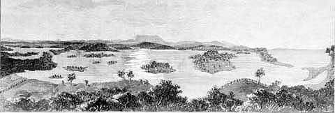
Mallacoota Inlet, as illustrated in this wood engraving, is a drowned valley of the Genoa River, formed when sea levels rose at the end of the Ice Ages. The much-indented inlet runs inland for about thirteen kilometres from the coast.
In this work, Samuel Calvert provides us with an elevated view of Mallacoota Inlet looking east towards Howe Range, with its 392 metre Howe Hill, in the middle distance. Off the coast to the right, and approximately fourteen kilometres in the distance is the long low profile of Gabo Island.
The Howe Range was formed around Devonian times, around 350 million years ago, when a granite batholith intruded surrounding Ordovician sediments, estimated to be around 500 to 435 million years old. This intrusion produced highly contorted Ordovician rocks, which today can be seen in the form of spectacular cliffs fronting the ocean. The whole region is of considerable geological interest and its long association with the Aborigines attracts the attention of many archaeologists. The area is also a sanctuary of animal and bird life, and within this remote and unique environment is a diverse range of botanical species.
Many artists have been drawn to this area, such as Lina Bryans, who have tried to capture something of the Aboriginal spirit of this region in their works. Writers and poets have also been drawn to the beauty and peacefulness of this area.
E.J. Brady and Henry Lawson spent 'some weeks' in 1910 in a bush camp at Mallacoota, and Lawson later wrote of the bar across the entrance to Mallacoota Inlet in his poem 'Mallacoota Bar'. The bar, known for its danger and the entrance to Mallacoota Inlet, is shown in the far right of the wood engraving.
Brady later recalled Lawson's visit, 'We were in our first camp on Captain's Point, living like gipsies. The fishing was good, the shooting was good and a temporary solving of the economic problem had left one free to write when and what one liked - in blessed literary emancipation and far enough from all that vulgar, strident condition that is miscalled 'modern civilization'.
Into this Aidenn walked Henry and Tom Mutch, his devoted friend - afterwards Minister for Education in two New South Wales governments.'
Brady further noted, that with reference to a later camp that they made, 'Australia has very few ruins of any historical importance; but for years local people used to point out, near Barracoota Lake, a place which was proudly known as "The Poet's Camp".'
Barracoota Lake referred to here by Brady, is one of the two freshwater lakes - the other is Lake Wau Wauka, which are situated between Mallacoota Inlet and Cape Howe. In the area of these lakes are extensive sand dunes and small swamps that dry up over summer.
Samuel Calvert depicts in this wood engraving the low sandy islands in the inlet that have a sparse covering of salt marsh. The small island in the centre is Goat Island, while the larger island to the right of Goat Island is Horse Island.
Calvert also depicts in the foreground a number of fence lines, showing that the area was being farmed at least as early as 1890.
It was around this time that gold was discovered on the rise above Cemetery Bight on the far eastern shores of 'Bottom Lake' and the ruins of the Spotted Dog Goldmine are still visible today only a short distance from the Pioneers Cemetery.
Calvert's view is from the western shore of 'Bottom Lake' from above what is now the main township of Mallacoota. The view is across 'Goodwin Sands' in the middle distance and beyond to 'Fairhaven'. To the left are 'The Narrows' and in the far left the 'Top Lake'. The two lakes are said to provide 322 kilometres of shoreline, which is approximately forty per cent more than the shoreline of Port Phillip Bay.
Further information on the artist Samuel Calvert is provided with the entry for his work 'Gabo Island Lighthouse'.
Further information:
The camp at Mallacoota
Copyright
Notice
No works
can be copied from this site. Permission to publish or reproduce can be
sought from the
State Library of Victoria.
All Rights Reserved medialaunch Pty. Ltd.
Left: Arthur Streeton
- Above Us The Great Grave Sky, 1890
Collection: National Gallery of Australia, Canberra.
ABN 69 067 524 921
Tel: +61 3 98185700 Fax: +61 3 98185044
Email: editor@artistsfootsteps.com