The Artists
Samuel Calvert
SAMUEL CALVERT
TIDAL RIVER, NORMAN
BAY, WILSON'S PROMONTORY c. 1876
SAMUEL CALVERT
Born 1828, Died 1913
TIDAL RIVER, NORMAN
BAY, WILSON'S PROMONTORY, c. 1876
print: wood engraving
Published in
the Illustrated Australian News
Melbourne: Ebenezer and David Syme, February 23, 1876
Collection:
La Trobe Picture Collection
State Library of Victoria
In July 1898, a temporary reserve of 3642 hectares was set aside at Wilsons Promontory under the Land Act, which listed this area under 'Sites for National Parks'.
For years, Wilsons Promontory National Park was known as 'The National Park', and today the park encompasses an area of approximately 49000 hectares.
The headquarters of the park are located at what is known as the Tidal River Resort, situated on the banks of the lower reaches of Tidal River. Tidal River Resort is approximately 230 kilometres south east of Melbourne and is 32 kilometres from the park entrance. It is situated on the south west of 'The Prom' as 'Wilsons Promontory' is popularly referred to, above Norman Bay and between Mount Bishop and Mount Oberon. Tidal River was a descriptive name given to the river that enters Bass Strait at Norman Bay.
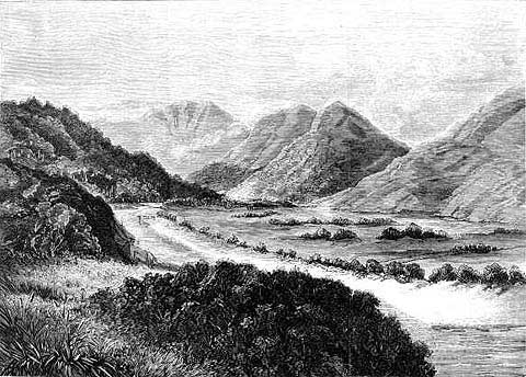
This early wood engraving by Samuel Calvert shows a somewhat different Tidal River to the one we know today. We now have a road to Tidal River Resort, which has developed on the land to the right in the engraving, which at that time was probably a very swampy area, and we now have bridges and walkways over the river. The Resort also has a Parks Victoria Centre, a range of shops and accommodation available.
In Calvert's work, Tidal River and its surrounding countryside appears in its wilderness state. The view is northeasterly, away from Norman Bay towards the heart of 'The Prom'. The base of Mount Bishop (319 metres) is on the left, Mount La Trobe (755 metres) is the furthest peak in the distance, left of centre, to its right is Mount Ramsay (686 metres), and to the far right in the foreground is the base of Mount Oberon (558 metres).
Over many years the low-lying areas between the mountain headlands, accumulated sand, and this developed long sandy beaches backed by vegetation, such as the beach at Norman Bay. This build up of sand also prevented the easy flow of the rivers and creeks, creating in many cases, swamps behind the sand dunes.
The swampy area of Tidal River is shown in this wood engraving, in the depression to the right of the river's course. In 1876, when this wood engraving was produced, 'The Prom', and Tidal River were areas to where few had travelled. In those days the 'Landing Place' for 'The Prom' was close to the lighthouse, approximately eighteen and a half kilometres from Tidal River. The lighthouse, built in 1859, would have been one of the few structures on 'The Prom' in 1876, and by 1884, passengers landing at 'The Prom', were captured in works by artists such as F.A. Sleap.
Wilsons Promontory National Park has since its establishment, been a favourite destination for bush walkers and nature lovers from around the World. It now attracts thousands of visitors every year, and the starting point for most of these visitors is the Tidal River Resort.
As early as 1915, 'The Prom' was advertised as a place for tourists, with 'an eight-day tour of the 'Prom' costing each party member 2 pounds 18 shillings and 4 pence, which included fare for railway, horse-drawn tram, motor boat, hire of pack horses, tents, provisions, and a camp assistant.'
In 1941, the Wilsons Promontory National Park was closed to the public and Australia's first commando units established training camps, which were connected by road, at Darby River and where the Tidal River Resort has since been developed. Darby River is situated approximately eight kilometres from Tidal River, and the buildings at Tidal River used by the commandos later became the nucleus for the Tidal River Resort.
By the 1940's these two areas of 'The Prom' were quite popular with tourists. A chalet had been built at Darby River as early as 1923, and huts existed at Tidal River and Sealers Cove at least as early as 1925. Protection of the unique and fragile wilderness environment found at Wilsons Promontory National Park has from the start been a challenge and a battle for Park Managers and many naturalists, against the interests of various outside groups, and against the forces of Nature.
The geographical location of Wilsons Promontory National Park puts it in the path of severe storms and fires are a yearly summer threat. One fire in February 1951 devastated the Park, with the destruction of approximately 30000 hectares.
Outside interests have included cattle, timber and mining. At one stage a tin mine was opened at Mount Hunter, near the Singapore Peninsula, that was named after the barque 'Singapore' which ran aground there. Thankfully however for the future of the Park, the tin mine only had a short history. Other outside interests included proposed subdivision and building schemes, and these date back to at least 1887.
There was even a proposal for the development of a town named 'Seaforth', and a site was surveyed near Mount Singapore. This town however, never eventuated.
In recent years the protection of 'The Prom' from developers has once again surfaced, and in 1998, a proposal to substantially re-develop the Tidal River Resort was quashed, after meeting with considerable objection.
Further information on the wood engraver, Samuel Calvert is provided with the entry for his work 'Gabo Island Lighthouse'.
Copyright
Notice
No works
can be copied from this site. Permission to publish or reproduce can be
sought from the
State Library of Victoria.
All Rights Reserved medialaunch Pty. Ltd.
Left:
Arthur Streeton - Above Us The Great Grave Sky, 1890
Collection: National Gallery of Australia, Canberra.
ABN 69 067 524 921
Tel: +61 3 98185700 Fax: +61 3 98185044
Email: editor@artistsfootsteps.com