The Artists
SKETCHES ON THE COAST,
1884
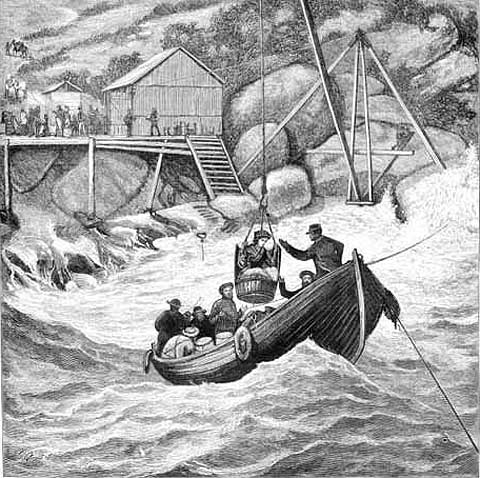
LANDING PASSENGERS AT WILSONS PROMONTORY

SKETCHES ON THE
COAST, 1884
LANDING PASSENGERS AT WILSONS PROMONTORY
print: wood engraving
Engraved by
F.A. Sleap and M.A.C.
Published in the Illustrated Australian News
Melbourne: David Syme & Co., May 14, 1884
Collection: La Trobe Picture Collection
State Library of Victoria
The 'Landing Place' at Wilsons Promontory was situated along the coast a short distance to the north of South East Point and the lighthouse. This is confirmed through the visual record provided by Albert Charles Cooke in his work 'The Skull Rocks and Landing Place, Wilson's Promontory' and the information provided by Baron Ferdinand von Mueller following his visit to Wilsons Promontory in 1874.
Why this became the 'Landing Place' is probably because this was the closest point to the lighthouse, where goods needed for the lighthouse could be unloaded without too much fear of loss. South East Point provided a little shelter from the southwesterly winds and high seas that batter the western coast of Wilsons Promontory.
This wood engraving by F.A. Sleap and M.A.C. of 1884, shows the precarious nature of landing at Wilsons Promontory at this time, which was as depicted, via a basket which was then hoisted to the safety of the shore. The method of leaving the promontory was just as hazardous with the passengers being hoisted in the basket to the awaiting boat off shore. The wooden landing platform or jetty was built on granite boulders, and in this work, women passengers in their long dresses and men in suits and top hats can be seen on the jetty watching the proceedings with some interest. A fall into the sea from the basket while wearing such attire would very likely have ended in the passenger being drowned.
It is interesting to note in this work the two horses on the steep track in the far left. The horses appear to be laden down with stores, and carry these towards the lighthouse that was situated on the rise above.
In the early days, there were other ways to visit Wilsons Promontory rather than risking this form of landing near the lighthouse. One way was by boat to one of the quiet coves along the eastern coast of the promontory, such as Refuge or Sealers Cove. However, opportunities for such a voyage were very limited.
Another way was by boat from Port Welshpool, which is situated approximately ten kilometres north of Extreme Point, the northern tip of the promontory. Port Welshpool derived its name from Montgomery County in Wales.
From Port Welshpool you would travel to the southern edge of Corner Inlet. Corner Inlet was named by George Bass in 1798, for its shape and location and is a large bay on the north east coast of Wilsons Promontory and south coast of the mainland.
Convicts from Tasmania knew of Corner Inlet, for it was here that they landed their stolen vessels on their way to the Victorian goldfields in the 1850's. From Corner Inlet, if you wanted to visit the promontory, you walked.
Some people ventured onto the promontory on horseback, however the rugged granite terrain, fern filled narrow gullies, mangrove flats, swamps and dense rainforests of Myrtle Beech, made such a venture fairly hazardous.
Years later, a track led from the small township of Fish Creek, situated approximately fourteen kilometres north of Waratah Bay, to Waratah Bay, situated to the north west of Wilsons Promontory. Waratah Bay was so named after the ship 'Waratah', captained by William Bell, sheltered there in 1854. The narrow Yanakie Peninsula isthmus separating Waratah Bay from Corner Inlet links Wilsons Promontory to the mainland. From Waratah Bay the visitor could, when the tide was out, follow a road made of planks over the beach to the mouth of the Darby River. But beyond Darby River, access again was only by horse or foot.
The wood engraving provided here is one from the series 'Sketches on the Coast' that was produced by F.A. Sleap and M.A.C. in 1884 for the Illustrated Australian News. Further information on these wood engravers is provided with the entry for their work 'Gabo Island (Victoria)'.
Copyright
Notice
No works
can be copied from this site. Permission to publish or reproduce can be
sought from the
State Library of Victoria.
All Rights Reserved medialaunch Pty. Ltd.
Left:
Arthur Streeton - Above Us The Great Grave Sky, 1890
Collection: National Gallery of Australia, Canberra.
ABN 69 067 524 921
Tel: +61 3 98185700 Fax: +61 3 98185044
Email: editor@artistsfootsteps.com